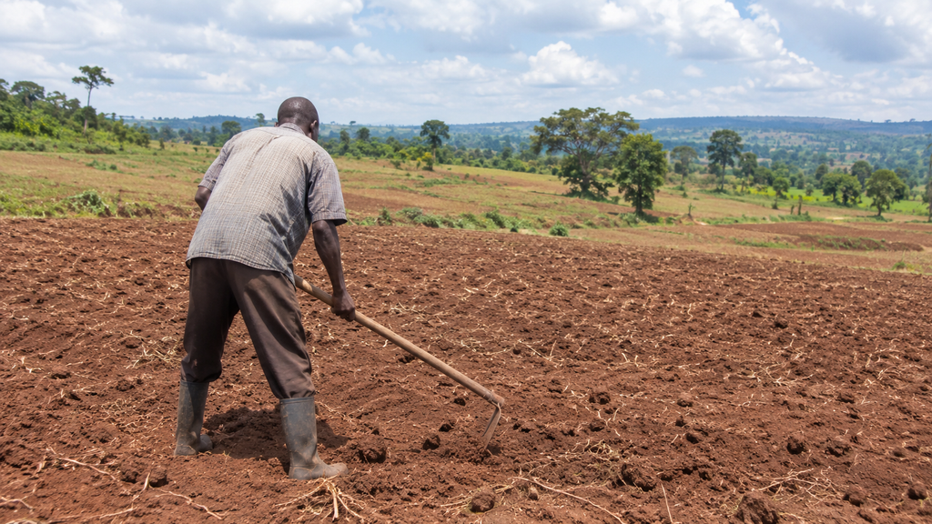

For maize farmer Paul Otieno in Migori County, the promise of October-to-December rain season was enough to get him preparing his fields. Like many farmers across the country, he had been waiting for the rains after successive poor seasons had disrupted planting and reduced harvests.
When weather forecasts indicated that rainfall would improve, thanks to expected El Niño, he took it as a signal to begin planting. But the expected rain did not arrive as anticipated, leaving him and other farmers facing the prospect of another difficult season.
“We were told there would be adequate rains within the first one week of October, and many of us took advantage of the prediction,” Otieno says.
His experience reflects a growing dilemma for farmers and pastoralists across Kenya on how to make critical livelihood decisions when seasonal forecasts point to favourable conditions, but the weather on the ground tells a different story.
The October-to-December short rains were expected to provide relief to communities still recovering from previous failed seasons. Instead, October and early November have brought prolonged dry conditions across large parts of eastern Kenya, the arid and semi-arid lands (ASALs), and sections of the central and coastal regions.
For pastoralists, the delay has meant further pressure on already strained grazing land and water sources. For crop farmers, it has disrupted planting schedules, raised the risk of seed losses and increased uncertainty over the season’s eventual harvest.
The disappointment has also revived questions about how seasonal forecasts are communicated, interpreted and translated into decisions by people whose livelihoods depend heavily on the weather.
In late September, the Kenya Meteorological Department projected fair-to-good rainfall in many parts of the country during the October-to-December season. Expectations were reinforced by the development of El Niño conditions in the Pacific Ocean, with some international climate models pointing to a particularly strong event. The prospect raised hopes of a wetter season, especially in areas that had endured repeated rainfall deficits.
But by November, rainfall distribution has fallen short of expectations in many locations. Some areas have received little rain, while others are experiencing rainfall that is too poorly distributed to support consistent crop growth and pasture regeneration.
The National Drought Management Authority (NDMA) is now warning that several ASAL counties are moving into Alert or Alarm drought phases, signalling worsening conditions, rising food insecurity and increasing pressure on water and pasture resources.
The uncertainty even attracted public attention at the highest level of government. Speaking at an agriculture summit in Nairobi in October, President William Ruto acknowledged the difficulty of predicting the arrival of the rains.
“Waiting for these rains involves guesswork,” he said. “We are waiting for El Niño, but we don’t know when it will arrive.” His remarks captured the frustration surrounding a season in which expectations had been raised by the prospect of El Niño, but rainfall has remained elusive in many parts of the country.
Meteorologists, however, caution against interpreting El Niño as a guarantee of above-average rainfall in Kenya. “El Niño is not synonymous with rainfall. So, El Niño is not rain,” says Joyce Kimutai, a principal meteorologist at the Kenya Meteorological Department.
El Niño is a climate phenomenon associated with the warming of sea surface temperatures in the central and eastern tropical Pacific Ocean. It influences atmospheric circulation and can alter rainfall patterns in different parts of the world. But its effects in East Africa depend on more than conditions in the Pacific, with one important influence being the Indian Ocean Dipole (IOD), a climate pattern defined by differences in sea surface temperatures between the western and eastern parts of the Indian Ocean.
When the IOD is in a strongly positive phase, warmer waters in the western Indian Ocean can enhance moisture supply towards East Africa, increasing the likelihood of heavier rainfall. When these conditions are absent, the rainfall response associated with El Niño may be weaker or different from what seasonal expectations suggest.
Kenya’s climate history illustrates this complexity. The devastating floods of 1997 occurred during a strong El Niño that coincided with a strongly positive Indian Ocean Dipole. The two climate influences contributed to exceptionally wet conditions across East Africa. The 2015 El Niño, although powerful, did not produce the same rainfall response in East Africa. The contrast demonstrates why the strength of an El Niño event alone cannot determine how much rain Kenya will receive.
Other atmospheric systems also influence when and where rainfall occurs. Kenyan meteorological officials have attributed the current delay partly to a low-pressure system over the northern Indian Ocean, which temporarily disrupted the southward movement of the Intertropical Convergence Zone (ITCZ).
The ITCZ is a belt of low atmospheric pressure near the equator where trade winds converge, creating conditions favourable for cloud formation and rainfall. Its seasonal movement towards and across East Africa is an important driver of the country’s rainfall seasons. When its movement is delayed or disrupted, the onset and distribution of rainfall can change, even when broader seasonal indicators point towards wetter conditions.
The difficulties facing farmers are also unfolding against a changing climate. Climate scientist Jackson Koimbori says climate change is amplifying natural climate variability, contributing to rainfall patterns that are increasingly difficult to predict at local level.
As the atmosphere warms, it can hold more moisture, creating the potential for heavier rainfall when suitable conditions develop. At the same time, higher temperatures increase evaporation and can accelerate the loss of moisture from soils, water bodies and vegetation. This combination can produce damaging swings between prolonged dry spells and intense rainfall.
For farmers, the timing and distribution of rainfall can matter as much as the seasonal total. A maize farmer who receives rain after the ideal planting window may still struggle to achieve a good harvest. Similarly, a pastoralist needs sustained rainfall over grazing areas to regenerate pasture and replenish water sources, rather than isolated heavy showers.
This makes the interpretation of seasonal forecasts particularly important. A forecast indicating enhanced chances of above-average rainfall does not mean that every county will receive adequate rain, or that rainfall will arrive at the beginning of the season. Seasonal forecasts describe probabilities over a broad geographical area and period, but they cannot guarantee the weather conditions a farmer will experience on a particular farm on a particular day.
The Kenya Meteorological Department’s early November advisory described conditions as unusually dry across much of the country and projected near- to below-average rainfall in December, with poor distribution.
The department has advised farmers to adopt moisture-conservation practices, including mulching and monitoring soil conditions. Livestock keepers were encouraged to conserve water and store animal feed in preparation for continued dry conditions.
Such measures are increasingly important in a country where millions of households depend on rain-fed agriculture and pastoralism. But the latest experience also points to the need to improve how climate information reaches the people who use it.
For Otieno and other farmers who planted in anticipation of the October rains, that distinction can determine whether the money spent on seeds, labour and land preparation produces a harvest or becomes another seasonal loss.
As climate variability makes rainfall increasingly difficult to anticipate, farmers and pastoralists cannot afford to treat a favourable seasonal outlook as a promise. They need forecasts that help them manage uncertainty, not merely anticipate the weather.